Category: Reading the Sky

An introduction to the fundamental workings of the heavens. These articles explore the celestial sphere, the apparent motions of the Sun, Moon, planets, and stars, lunar phases, seasons, eclipses, and other essential concepts that help explain what we see when we look up.

  • Latitude and longitude: the grid that conquered the world

    Latitude and longitude: the grid that conquered the world

    Imagine standing on the deck of a ship in the middle of the Atlantic Ocean. No landmarks. No GPS. No radio. Nothing but water in every direction and a sky full of stars overhead.

    For most of human history, that wasn’t a thought experiment. It was reality.

    If you wanted to know where you were, you had to figure it out yourself. Entire fortunes, military campaigns, trade routes, and human lives depended on it. A ship that missed its destination by a few degrees might arrive hundreds of miles from its intended port, or worse, wreck itself on unseen reefs and rocky coastlines.

    The solution to this problem was one of humanity’s greatest navigational achievements: an invisible grid wrapped around the Earth known as latitude and longitude.

    Today, we barely think about it. We tap an address into a phone, drop a pin on a map, and let satellites do the hard work. But behind that simple blue dot lies a fascinating story involving astronomy, mathematics, exploration, and one stubborn clockmaker who spent decades trying to solve a problem many experts thought was impossible.

    Wrapping a grid around a globe

    Because the Earth is roughly spherical, finding a precise location requires more than simply saying “go north” or “head west.” We need a way to describe any point on the planet using a consistent set of coordinates. Latitude and longitude provide exactly that.

    Together, they form a global coordinate system that can identify virtually any location on Earth, from the summit of Mount Everest to your favorite neighborhood coffee shop.

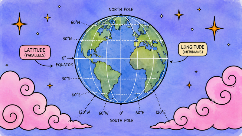
    The system works by dividing the Earth with two sets of imaginary lines. One set runs east and west around the globe. The other runs north and south from pole to pole. Where those lines intersect, you have a unique address for a specific location.

    Latitude: the easy one

    Latitude measures how far north or south you are from the Equator.

    If you’ve ever looked at a globe and noticed horizontal rings circling the planet, you’ve seen lines of latitude. Because these lines remain parallel to one another, they are often called parallels.

    The Equator serves as the natural starting point and is assigned a latitude of 0°. From there, latitude increases as you travel north or south. The North Pole sits at 90° North latitude, while the South Pole lies at 90° South latitude. Everything north of the Equator belongs to the Northern Hemisphere. Everything south belongs to the Southern Hemisphere.

    Several famous lines of latitude also divide the globe into important climate and daylight regions. The Tropic of Cancer lies at approximately 23.5° North, while the Tropic of Capricorn sits at roughly 23.5° South. Farther toward the poles are the Arctic and Antarctic Circles at approximately 66.5° North and South.

    Unlike many human-made systems, latitude is based on a natural feature of the Earth itself. The Equator exists whether humans recognize it or not, making it an obvious reference point from which to measure.

    Latitude also has a direct connection to the sky.

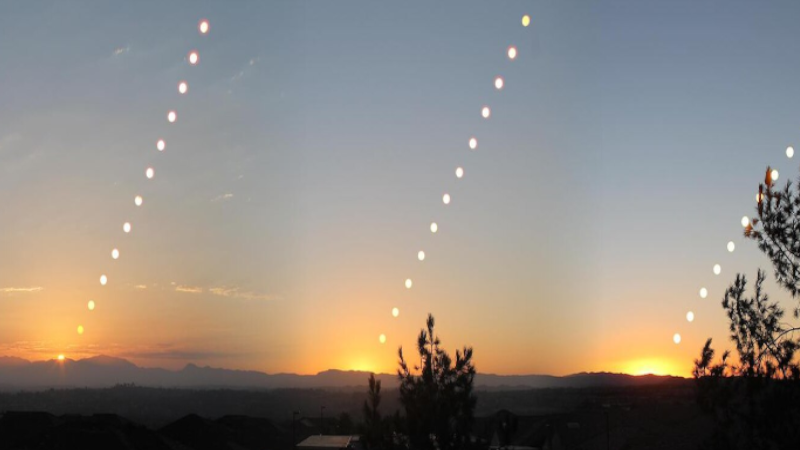
    If you’ve been following our Reading the Sky series, you’ll remember that the celestial poles appear at different heights above the horizon depending on where you are on Earth. In fact, the altitude of the North Celestial Pole above your northern horizon is equal to your latitude.

    At the North Pole, the celestial pole sits directly overhead. At the Equator, it rests on the horizon. Everywhere else falls somewhere in between.

    This relationship made latitude surprisingly easy for navigators to determine. By measuring the height of Polaris above the horizon, sailors could estimate their north-south position with remarkable accuracy.

    Longitude, unfortunately, was not nearly so cooperative.

    Longitude: the difficult one

    Longitude measures how far east or west you are.

    The lines of longitude, called meridians, run from the geographic North Pole to the geographic South Pole. Unlike lines of latitude, all meridians eventually meet at the poles.

    This creates an immediate problem.

    The Earth has an obvious equator, but it doesn’t have an obvious starting meridian.

    Nature gives us a north-south axis. It does not give us an east-west zero point.

    Humans had to choose one.

    Today, that reference line is known as the Prime Meridian. It passes through Greenwich, England, at the site of the historic Royal Observatory. By international agreement, this location was designated 0° longitude in the late nineteenth century.

    From there, longitude is measured east and west up to 180°, where the two halves of the globe meet on the opposite side of the planet.

    Once you know both your latitude and your longitude, you can identify your position anywhere on Earth with remarkable precision.

    Reading coordinates

    You may have seen coordinates written using degrees (°), minutes (′), and seconds (″).

    This system traces its roots back thousands of years to ancient Babylonian mathematics, which divided circles into 360 degrees and counted using groups of sixty rather than ten.

    A coordinate such as:

    33° 51′ 30″ S, 151° 12′ 53″ E

    means 33 degrees, 51 minutes, and 30 seconds south of the Equator, and 151 degrees, 12 minutes, and 53 seconds east of the Prime Meridian.

    Today, you’re more likely to encounter decimal coordinates instead. Modern GPS systems and mapping software typically express locations as decimal degrees. For example, the Library of Congress in Washington, D.C. is located at approximately:

    38.888611, -77.004722

    In this format, positive numbers generally indicate north latitude and east longitude, while negative numbers indicate south latitude and west longitude.

    But what does a degree actually represent?

    A degree of latitude corresponds to roughly 111 kilometers (69 miles) anywhere on Earth. Longitude is a little trickier. At the Equator, a degree of longitude is also about 111 kilometers wide, but the meridians gradually converge as they approach the poles. By the time you reach either pole, the distance between lines of longitude shrinks to essentially zero.

    Those numbers are useful on paper.

    Actually determining your coordinates while standing on the deck of a rolling ship in the middle of the ocean was another matter entirely.

    The longitude problem

    For centuries, sailors could determine latitude with reasonable confidence. The sky practically handed them the answer.

    In the Northern Hemisphere, the altitude of Polaris above the horizon closely matches your latitude. If Polaris appeared 40 degrees above the northern horizon, you were at roughly 40° north latitude. Even when Polaris wasn’t visible, navigators could use the Sun and stars to estimate their position.

    Longitude was a different beast altogether. A captain might know exactly how far north or south he was and still have no reliable way to determine how far east or west he had traveled. The consequences could be catastrophic.

    A ship crossing the Atlantic might miss its destination by hundreds of miles. Fleets could become separated. Merchant vessels could sail directly into dangerous shoals or reefs. Entire voyages could be ruined because nobody knew their exact east-west position.

    The challenge became so important that it was eventually known simply as The Longitude Problem. Solving it would require a breakthrough in both astronomy and timekeeping.

    Why longitude is really a time problem

    The key insight is surprisingly simple. The Earth rotates 360 degrees in 24 hours. That means it turns:

    • 15 degrees every hour
    • 1 degree every 4 minutes

    If you know the local time where you are and the time at a known reference location, you can calculate your longitude.

    Imagine it’s noon on your ship because the Sun has reached its highest point in the sky. If a clock set to Greenwich time reads 2:00 PM, then Greenwich is two hours ahead of you. Two hours multiplied by 15 degrees per hour equals 30 degrees. You are therefore approximately 30 degrees west of Greenwich.

    Simple. At least in theory. The problem was that nobody could build a clock capable of keeping accurate time during a months-long sea voyage.

    The clock worth a fortune

    In the early eighteenth century, the longitude problem had become so severe that the British government decided to put a price on the solution. A very large price.

    In 1714, during the reign of Queen Anne, Parliament passed the Longitude Act, offering rewards of up to £20,000 to anyone who could develop a practical method for determining longitude at sea. Adjusted for modern values, the prize was worth several million dollars.

    The challenge wasn’t understanding what was needed. By this point, many scientists already recognized that accurate timekeeping held the key. More than half a century earlier, the Dutch astronomer, mathematician, and inventor Christiaan Huygens had dramatically improved the accuracy of clocks with his invention of the pendulum clock. He was among the first to recognize that precise timekeeping could provide a solution to the longitude problem, and he later developed the balance spring that would become a crucial component of portable timepieces.

    Unfortunately, pendulum clocks proved too sensitive to the constant motion of a ship. The real challenge was not identifying the solution in theory, but building a clock that could keep accurate time through months of rolling seas, changing temperatures, salt air, and storms.

    Many of Europe’s greatest scientists believed astronomy would ultimately provide the answer. The man who finally solved the problem, however, wasn’t an astronomer. He was a carpenter.

    John Harrison and the impossible clock

    John Harrison had no university education and no aristocratic connections. He was a self-taught clockmaker from rural England. Where others searched the skies for a solution, Harrison focused on the clock.

    The best timekeepers of the era were pendulum clocks. They worked wonderfully in homes and observatories. They were terrible aboard ships.

    A rolling vessel constantly disrupted the pendulum’s swing. Changes in temperature caused components to expand and contract. Salt air corroded metal parts. Vibrations introduced errors.

    Even tiny inaccuracies accumulated over weeks and months. And a small error in time translated into a large error in longitude.

    Harrison became obsessed with solving the problem. His first design, known as H1, looked less like a clock and more like a piece of scientific machinery. Instead of a pendulum, it used interconnected balancing mechanisms designed to counteract the ship’s motion. The entire device was mounted in gimbals so it could remain relatively level even when the vessel pitched and rolled.

    It worked. But Harrison wasn’t satisfied. Over the next three decades, he continued refining and improving his designs. Each version came closer, and finally, in 1759, Harrison completed H4.

    Unlike his earlier machines, H4 resembled an oversized pocket watch. It was compact. Durable. Astonishingly accurate. Most importantly, it could keep time during long sea voyages. For the first time in history, navigators could carry a reliable reference clock across the ocean.

    The longitude problem was effectively solved. After centuries of uncertainty, sailors finally had a dependable way to determine their east-west position anywhere on Earth. The oceans suddenly became a much smaller place.

    Time zones and traveling to yesterday

    The connection between longitude and time didn’t disappear once sailors learned how to navigate the oceans. In fact, it’s still baked into the way we organize our clocks today.

    The word meridian comes from Latin roots meaning “middle” and “day,” referring to the moment when the Sun reaches its highest point in the sky: noon. The familiar abbreviations a.m. and p.m. come from the Latin phrases ante meridiem (“before midday”) and post meridiem (“after midday”).

    For most of human history, every town simply set its clocks according to the Sun. When the Sun reached its highest point overhead, it was noon. Simple. The problem was that noon doesn’t happen everywhere at the same time.

    A town located a few miles west of another town experiences local noon a few minutes later. Before fast transportation and long-distance communication, this wasn’t much of an issue. People rarely traveled far enough or fast enough to notice. Then came the railroads.

    By the middle of the nineteenth century, trains were crisscrossing countries at speeds never before possible. Every city maintained its own local time, creating a scheduling nightmare. Travelers had to constantly adjust their watches, railroad timetables became increasingly complicated, and telegraph operators struggled to coordinate communications between distant locations.

    Something had to change. The solution? Divide the Earth into broad regions that would all share the same standard time.

    Because the Earth rotates 360 degrees in 24 hours, it turns approximately 15 degrees every hour. That makes 15 degrees of longitude a convenient unit for a time zone.

    In practice, political borders, geography, and human stubbornness have produced plenty of exceptions, but the underlying principle remains the same. As you travel east or west around the globe, local time changes because longitude and the Earth’s rotation are fundamentally linked.

    This raises an interesting question. What happens if you keep traveling?

    Imagine heading west around the Earth, adjusting your watch backward hour by hour as you cross each time zone. Eventually, you’ve gone all the way around the planet. Your clock says one thing. Your calendar says another. And suddenly you’ve stumbled into a paradox.

    If every hour traveled west takes you further back in local time, then completing a full circuit of the globe would seem to put you a full day behind everyone who stayed home.

    Clearly, something has to give. The solution is the International Date Line.

    Located roughly along the 180th meridian in the Pacific Ocean, the International Date Line serves as the place where the calendar resets itself. It zigzags around island groups and political boundaries, but its purpose is straightforward: to keep the world’s dates synchronized.

    Cross it traveling west, and the calendar advances by one day. Cross it traveling east, and the calendar moves back by one day. You aren’t actually traveling through time, of course. But it’s probably the closest most of us will ever come.

    Beyond the Earth

    Although latitude and longitude were developed to describe locations on Earth, astronomers eventually adapted similar ideas for mapping the sky itself.

    After all, if you can create a coordinate system for a planet, why not create one for the celestial sphere?

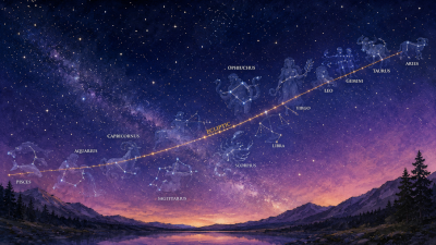
    Instead of latitude, astronomers use a coordinate called declination. Like latitude, declination measures angular distance north or south, but instead of using the Earth’s equator, it uses the celestial equator projected onto the sky.

    Instead of longitude, astronomers use right ascension, which measures positions eastward around the celestial sphere.

    Unlike terrestrial longitude, right ascension is usually expressed in hours, minutes, and seconds of time rather than degrees. This might seem strange until you remember that the sky itself appears to rotate because of the Earth’s rotation. Since the Earth turns 15 degrees every hour, expressing celestial coordinates in units of time becomes remarkably convenient.

    Together, right ascension and declination allow astronomers to pinpoint stars, galaxies, nebulae, planets, and countless other celestial objects with extraordinary precision.

    If you’ve ever used a computerized telescope, looked up the coordinates of a deep-sky object, or followed a star chart, you’ve already encountered the celestial descendants of latitude and longitude.

    A grid worth remembering

    Latitude and longitude are often taught as geography. Their history, however, is deeply tied to astronomy.

    Navigators measured the height of stars above the horizon to determine latitude. Astronomers mapped the heavens to aid exploration. Clockmakers built astonishingly precise instruments so sailors could compare one meridian to another. Together, they solved one of the greatest scientific and technological challenges of the age.

    In a very real sense, humanity learned to navigate the Earth by learning to read the sky.

    Today, your phone can determine your position within a few feet almost instantly. Satellites, atomic clocks, and computers handle calculations that once required years of study and some of the finest instruments ever built. Yet every time you check a map, search for an address, or glance at a GPS screen, you’re still relying on the same invisible framework that guided explorers across unknown oceans centuries ago.

    Not bad for a few imaginary lines wrapped around a spinning sphere.

  • Solstices and equinoxes: the Sun’s annual journey

    Solstices and equinoxes: the Sun’s annual journey

    If you’ve ever watched where the Sun rises over the course of a year, you may have noticed something surprising. It doesn’t always come up in the same place.

    Most of us grow up with the idea that the Sun rises in the east and sets in the west. That’s true in a general sense, but it’s only exactly true on two days each year. The rest of the time, the Sun is slowly wandering.

    In summer, it rises north of east and sets north of west. In winter, it rises south of east and sets south of west. Day by day, week by week, the position shifts so gradually that most people never notice it.

    Ancient peoples, however, absolutely noticed.

    Long before clocks, calendars, weather forecasts, or smartphone reminders, the changing position of the Sun served as one of humanity’s most reliable indicators of the seasons. Knowing when to plant, harvest, travel, hunt, or prepare for winter could be a matter of survival.

    The reason the Sun appears to wander across our horizon is the same reason we experience seasons in the first place: Earth’s axis is tilted.

    As we discussed in our article on the ecliptic, Earth’s rotational axis is tilted about 23.5 degrees relative to its orbit around the Sun. Because of that tilt, the Sun appears to follow a path through the sky that is inclined relative to the celestial equator.

    As the year progresses, the Sun slowly moves northward and southward against the background of the stars, tracing out an annual cycle that gives us the solstices and equinoxes.

    The Equinoxes: Days of Balance

    Twice each year, the Sun crosses the celestial equator. These moments are known as the equinoxes, a word derived from Latin meaning “equal night,” because on these dates, day and night are approximately equal in length all over the world.

    The vernal, or spring, equinox occurs around March 20 or 21, when the Sun crosses from the southern half of the celestial sphere into the northern half. Roughly six months later, around September 22 or 23, the autumnal equinox occurs as the Sun makes the return journey southward.

    The equinoxes are also the only times during the year when the Sun rises almost exactly due east and sets almost exactly due west. Every other day of the year, it rises and sets somewhere else.

    If you were to mark the position of sunrise on the horizon every morning, you’d see it steadily drift northward after the spring equinox, reach its northernmost point in June, then begin moving southward again until December.

    It’s a slow-motion celestial pendulum that has been keeping time for our species for thousands of years.

    The Solstices: When the Sun Seems to Stand Still

    Midway between the equinoxes, the Sun reaches the northernmost or southernmost point of its annual journey. These are the solstices, the word coming from the Latin solstitium, meaning “the Sun stands still.”

    Of course, the Sun isn’t actually stopping. But if you carefully track its daily movement along the horizon, you’ll notice that its northward or southward progress slows dramatically near these turning points. For several days, its position changes very little before reversing direction.

    To ancient observers, it genuinely appeared as though the Sun had paused.

    The summer solstice occurs around June 20 or 21 in the Northern Hemisphere. On this day, the Sun reaches its greatest northern declination, about 23.5 degrees north of the celestial equator. It is also the longest day and shortest night of the year for those of us north of the Equator.

    The winter solstice occurs around December 21 or 22, when the Sun reaches its southernmost point and we experience the shortest day and longest night of the year.

    These four seasonal markers, two equinoxes and two solstices, divide the Earth’s annual journey around the Sun into quarters and form the backbone of many traditional calendars.

    The Tropics, the Arctic, and Everything In Between

    The Sun’s yearly north-south journey also defines some of the most important geographic regions on Earth.

    Between 23.5° north and 23.5° south latitude lie the tropics. Somewhere within this region, the Sun can appear directly overhead at noon during part of the year.

    The northern boundary is known as the Tropic of Cancer, while the southern boundary is the Tropic of Capricorn. These names come from the zodiac constellations in which the Sun appeared thousands of years ago when these lines were first defined.

    Farther north and south are the Arctic and Antarctic Circles at approximately 66.5° latitude.

    Beyond these boundaries, something remarkable happens. There are times of the year when the Sun never rises. And other times when it never sets. The closer you travel toward either pole, the more extreme these effects become, culminating in months of continuous daylight or darkness near the poles themselves.

    The same 23.5-degree tilt that gives us pleasant spring afternoons and long summer evenings is also responsible for the midnight sun of the Arctic and the long polar night of winter.

    Reading the Seasons

    The changing position of the Sun has served as a calendar for humanity for thousands of years.

    One of the most famous examples is Stonehenge in southern England. While its exact purpose remains a matter of debate, the monument appears to have been carefully aligned with the movements of the Sun. On the summer solstice, an observer standing within the circle sees the rising Sun appear in alignment with key stones and earthworks.

    But Stonehenge is far from unique. Cultures around the world built monuments, temples, observatories, and ceremonial sites designed to mark the turning points of the year. The details varied, but the goal was often the same: to track the Sun’s annual journey and anticipate the changing seasons.

    For people whose lives depended on agriculture, migration, trade, or ritual observance, these celestial milestones weren’t abstract astronomical concepts; they were practical tools. The sky was a calendar. And the Sun was one of its most important hands.

  • Why the Sun rises and sets

    Why the Sun rises and sets

    Every morning, the Sun rises in the east. Every evening, it sinks toward the western horizon and disappears. It’s such a familiar part of daily life that most of us rarely stop to think about it. The Sun comes up. The Sun goes down. Day follows night. Repeat approximately forever. Simple, right?

    Well… not exactly. Because the Sun isn’t actually rising. Or setting. In fact, from the Sun’s perspective, it’s mostly minding its own business while we are the ones doing all the moving.

    The Great Cosmic Illusion

    Imagine standing in an open field on a clear morning. The eastern horizon begins to glow. The sky brightens. Eventually, the upper edge of the Sun peeks above the horizon and climbs into the sky.

    Everything about the experience suggests that the Sun is moving. After all, you can watch it happen.

    But appearances can be deceiving. The Sun only seems to move because Earth is rotating. Our planet spins eastward on its axis once approximately every twenty-four hours. As it turns, different parts of Earth’s surface rotate into sunlight and then back out again. Day and night are simply the result of living on a spinning world.

    The Sun doesn’t travel around Earth every day. Earth turns beneath the Sun.

    A Spinning Planet

    Earth rotates at a surprisingly impressive speed. At the equator, someone standing perfectly still is actually moving at roughly 1,000 miles per hour (about 1,600 kilometers per hour) as the planet spins beneath their feet.

    Fortunately, everything around us is moving at the same speed, including the atmosphere, the oceans, and the ground itself, so we don’t feel the motion. Instead, the world feels stable while the sky appears to move.

    This apparent motion is one of the most important concepts in astronomy. Astronomers call it diurnal motion, from the Latin word for “daily.”

    Diurnal motion is responsible for:

    • Sunrise and sunset
    • Moonrise and moonset
    • The apparent movement of stars across the sky
    • The nightly rotation of constellations

    In other words, much of what we perceive as celestial motion is actually the result of Earth’s rotation.

    Why the Sun Rises in the East

    If Earth rotates eastward, why does the Sun appear to move westward? The answer becomes easier to understand if you’ve ever ridden a merry-go-round.

    When you spin in one direction, everything around you seems to move in the opposite direction. Earth works the same way.

    Because our planet rotates toward the east, the Sun appears to drift toward the west. That’s why the Sun rises in the eastern sky and sets in the western sky.

    The same apparent motion affects the Moon, planets, and stars. It’s all part of the same illusion.

    Is the Sun Ever Directly Overhead?

    Sometimes. But only in certain parts of the world.

    Because Earth is tilted about 23.5 degrees on its axis, the Sun’s path across the sky changes throughout the year. Near the equator, the Sun can pass almost directly overhead at certain times. Farther north or south, it never quite reaches that position.

    This changing path is one of the reasons we experience seasons, a topic we’ll explore in a future article. For now, it’s enough to know that the Sun’s daily journey across the sky isn’t exactly the same every day. The details change as Earth continues its yearly orbit around the Sun.

    What About the Stars?

    Once the Sun sets, the same pattern continues.

    Look toward the night sky and you’ll notice the stars appear to rise in the east and set in the west, just like the Sun.

    Ancient skywatchers carefully observed this motion and used it for navigation, timekeeping, and seasonal planning.

    Some stars seem to circle around Polaris, the North Star, without ever dipping below the horizon. These are called circumpolar stars. Others rise and set each night. All of them are participating in the same apparent motion caused by Earth’s rotation.

    The stars aren’t spinning around us. We’re spinning beneath them.

    A Tiny Daily Difference

    If you’ve spent time observing the night sky, you may have noticed something curious. The stars rise about four minutes earlier each night.

    This happens because Earth isn’t just rotating. It’s also orbiting the Sun.

    Each day, our planet moves a little farther along its annual path. To bring the Sun back to the same position in the sky, Earth has to rotate just a little bit extra.

    The result is that the stars slowly shift from night to night and season to season. It’s why winter constellations eventually give way to spring constellations, which yield to summer skies and autumn stars.

    The heavens are not standing still. They’re revealing Earth’s journey around the Sun.

    Looking Ahead

    The daily motion of the sky is one of the easiest astronomical patterns to observe. It happens every day, whether we’re paying attention or not. Yet understanding it unlocks a much deeper realization.

    The Sun’s daily path isn’t random. Neither is the Moon’s. Neither are the stars’. All of these motions take place against a larger celestial framework, one that ancient astronomers used to map the heavens and that modern astronomers still rely on today.


    Featured image: Photograph © 2026 by Sunny Simmons.

  • The celestial sphere: an imaginary tool for visualizing the heavens

    The celestial sphere: an imaginary tool for visualizing the heavens

    If you’ve ever watched the stars wheel overhead on a clear night, you’ve probably noticed something strange. Everuthing seems to be moving.

    The Sun rises in the east and sets in the west. The Moon drifts across the sky. Constellations appear to rotate around the North Star. Even the planets wander slowly among the stars over time.

    It certainly looks like the heavens are spinning around us.

    Of course, we know better. Or at least, we think we do.

    Most of us learn at a young age that Earth rotates on its axis once every twenty-four hours. The Sun isn’t actually circling us. Neither are the stars. We are the ones doing the moving.

    So why do astronomers still talk about the sky as though it were wrapped around Earth? Because sometimes an illusion is useful.

    Enter the celestial sphere.

    A useful fiction

    The celestial sphere is one of astronomy’s oldest and most useful ideas.

    Imagine standing outside on a clear night. Now imagine that the entire sky is actually the inside surface of an enormous hollow sphere surrounding Earth. Every star, planet, and constellation appears painted on the inside of that sphere. You’re standing at the center.

    That’s the celestial sphere.

    Is it real? Not even a little. The stars are not attached to a giant dome. Some are relatively nearby neighbors within our galaxy, while others are hundreds or thousands of light-years farther away. The planets are much closer. The Moon is closer still. In reality, space is a vast three-dimensional expanse.

    But from our perspective here on Earth, everything appears projected onto a single celestial backdrop. The celestial sphere gives us a convenient way to describe what we see without constantly worrying about actual distances.

    Think of it as the astronomical equivalent of a map. A road map isn’t the landscape itself. It’s a simplified representation that helps us navigate. The celestial sphere serves the same purpose for the sky.

    Why everything appears to move

    If the celestial sphere were real, it would appear to rotate around us once every day. Of course, what’s actually happening is that Earth is spinning.

    Our planet rotates eastward, completing one full turn roughly every twenty-four hours. Because of that rotation, the sky appears to move westward. This apparent movement is called diurnal motion, from the Latin word for “daily.”

    It’s responsible for:

    • Sunrise and sunset
    • Moonrise and moonset
    • The apparent movement of stars across the sky
    • The nightly turning of the constellations

    Imagine sitting on a merry-go-round. As you spin, the world around you appears to move in the opposite direction. The same thing happens on Earth. We’re riding a spinning planet, and the sky only seems to be doing the dancing.

    The celestial poles

    Now let’s stretch Earth’s geography into space.

    If you could extend Earth’s axis outward beyond the North and South Poles, those imaginary lines would eventually intersect the celestial sphere. Those points are called the celestial poles.

    For observers in the Northern Hemisphere, one star sits remarkably close to the north celestial pole: Polaris, commonly known as the North Star.

    Polaris isn’t especially bright, nor is it particularly unusual. Its fame comes from its location.

    Because it lies almost directly above Earth’s rotational axis, Polaris appears nearly stationary while the rest of the sky slowly circles around it.

    If you’ve ever seen photographs of star trails forming concentric circles around a fixed point in the sky, you’ve seen the celestial pole in action. The stars aren’t actually orbiting Polaris. We’re simply watching Earth turn beneath them.

    The celestial equator

    Just as Earth’s poles can be projected into space, so can Earth’s equator. The result is the celestial equator, an imaginary line wrapped around the celestial sphere directly above Earth’s equator.

    This celestial equator divides the sky into northern and southern halves. Astronomers use it as one of the primary reference lines for locating objects in the sky, much like geographers use Earth’s equator when describing locations on our planet.

    Again, none of these lines actually exist. No giant glowing circle hangs in the heavens. But these invisible reference points allow astronomers to create a coordinate system for the sky that works remarkably well.

    Your place changes everything

    One of the most fascinating aspects of the celestial sphere is that everyone sees a slightly different version of it. Where you stand on Earth matters.

    Someone standing near the equator can see portions of both the northern and southern skies. They have access to a vast celestial panorama.

    Someone living much farther north sees a different view. Certain southern constellations never rise above the horizon at all.

    Meanwhile, observers in the Southern Hemisphere enjoy constellations that many northerners will never see.

    The sky isn’t changing. Your vantage point is. The celestial sphere reminds us that every observation begins somewhere. Every sky has a point of view.

    Why astronomers still use it

    At this point, you might reasonably ask why modern astronomers still bother with a model that isn’t physically real. The answer is simple. Because it works.

    When we observe the sky from Earth, we’re interested in where things appear to be. The celestial sphere provides a practical framework for describing those positions. It’s the foundation of star charts, telescope alignment systems, celestial coordinates, and countless other tools astronomers rely on every day.

    Sometimes the best way to understand something complex is not to model reality exactly, but to model what we actually experience. The celestial sphere does exactly that. It’s an imaginary object that doesn’t exist. And yet, for thousands of years, it has helped humanity make sense of the heavens.

    Not bad for a giant invisible ball.

    Looking ahead

    Now that we have our celestial stage, we can begin examining some of the actors moving across it.

    In the next article, we’ll explore one of the most important paths in the sky: the ecliptic, the invisible track traced by the Sun across the celestial sphere and the foundation of seasons, eclipses, the zodiac, and much of humanity’s oldest sky lore.


    Featured image: Original artwork © 2026 by Sunny Simmons.

  • The Zodiac is a real place: constellations, the ecliptic, and humanity’s most famous sky map

    The Zodiac is a real place: constellations, the ecliptic, and humanity’s most famous sky map

    Mention the zodiac and most people immediately think of horoscopes. Perhaps you’re a Leo. Or a Pisces. Maybe you’ve been told you’re incompatible with a Gemini, destined to marry a Scorpio, or doomed to have a terrible week because Mercury is doing something dramatic.

    But whatever your opinion of astrology, there’s something important worth knowing: the zodiac is real. Not necessarily in the way modern horoscopes describe it, but as an actual region of the sky.

    Long before the zodiac became associated with personality traits and newspaper columns, it served as one of humanity’s most practical astronomical tools. Ancient skywatchers used it to track the movements of the Sun, Moon, and planets, measure the passage of time, and organize their observations of the heavens.

    In other words, the zodiac began as astronomy.

    A Road Through the Stars

    In a previous article, we explored the ecliptic: the apparent path the Sun follows across the celestial sphere over the course of a year. Because the planets orbit the Sun in nearly the same plane, they also appear to travel close to this path. The Moon spends most of its time nearby as well.

    This creates a special band of sky surrounding the ecliptic. The constellations that occupy this celestial neighborhood form what we know as the zodiac.

    Rather than being scattered randomly across the heavens, the zodiac constellations sit along the great highway traveled by the Sun, Moon, and planets. If the ecliptic is the road, the zodiac is the collection of landmarks along the way.

    What Is a Constellation?

    Before we go further, let’s talk about constellations. A constellation is simply a recognized region of the sky.

    Many people imagine constellations as groups of stars connected into stick figures. While those familiar patterns are part of the story, modern astronomy treats constellations somewhat differently. Today, the sky is officially divided into 88 constellations. Every point in the heavens belongs to one of them.

    Think of constellations as celestial countries drawn on an imaginary map. The stars themselves may be separated by vast distances. They only appear close together from our perspective on Earth.

    The constellation boundaries, however, provide a useful way to identify locations in the sky. The zodiac constellations are simply the constellations through which the ecliptic passes.

    The Traditional Zodiac

    Most people are familiar with the twelve traditional zodiac signs:

    • Aries
    • Taurus
    • Gemini
    • Cancer
    • Leo
    • Virgo
    • Libra
    • Scorpio
    • Sagittarius
    • Capricorn
    • Aquarius
    • Pisces

    These constellations form a rough ring around the sky and have been used for thousands of years to track celestial motion.

    As the year progresses, the Sun appears to move through each of these constellations in turn. The Moon follows a similar path. The planets wander among them.

    For ancient observers, the zodiac provided a convenient celestial calendar. If someone said Mars was in Taurus or the Moon was near Gemini, other skywatchers immediately knew where to look.

    The Constellation Everyone Forgets

    At this point, some readers may be thinking: “Wait a minute. Aren’t there actually thirteen zodiac constellations?”

    Astronomically speaking, yes.

    The ecliptic passes through a constellation called Ophiuchus, the Serpent Bearer. Located between Scorpius and Sagittarius, Ophiuchus occupies a portion of the ecliptic that the Sun traverses every year.

    This means the Sun actually spends time in thirteen constellations, not twelve. So why isn’t Ophiuchus included in most zodiac systems? The answer is historical rather than astronomical.

    Ancient astrologers divided the ecliptic into twelve equal sections because twelve fit neatly with existing calendars and seasonal cycles. The signs of astrology became symbolic divisions of the sky rather than precise representations of the actual constellation boundaries.

    The twelve-sign zodiac remained. Ophiuchus got left out.

    The stars, naturally, did not care.

    Signs Are Not Constellations

    This distinction is one of the most commonly misunderstood aspects of the zodiac. The zodiac signs used in most Western astrology are not the same thing as the zodiac constellations.

    Constellations vary dramatically in size. Virgo occupies a large region of the sky. Scorpius is comparatively small. Ophiuchus sits right in the middle of the action.

    The astrological zodiac, however, divides the ecliptic into twelve equal thirty-degree segments. Those segments are called signs.

    Originally, the signs roughly corresponded to the constellations that shared their names. Over time, however, the two systems drifted apart.

    The Slow Wobble of Earth

    Part of the reason for this drift is a phenomenon called precession.

    Earth does not spin perfectly upright like a toy top. Instead, its rotational axis slowly wobbles over time. One complete wobble takes about 26,000 years.

    As Earth wobbles, the position of the equinoxes gradually shifts relative to the stars. Two thousand years ago, the Sun’s position during the spring equinox aligned more closely with the constellation Aries. Today, that same point lies in Pisces and is slowly moving toward Aquarius.

    This means the modern astrological signs no longer line up perfectly with the constellations from which they originally took their names. The stars have moved only slightly. Our reference points have shifted.

    Why Ancient Cultures Cared

    The zodiac was one of humanity’s earliest celestial coordinate systems. It provided a framework for tracking the movements of the Sun, Moon, and planets. It helped organize calendars and seasonal observations. It aided navigation. It allowed astronomers separated by great distances and centuries of time to describe what they were seeing.

    But the zodiac was never merely practical. Humans are storytellers.

    The constellations became heroes, animals, monsters, rulers, hunters, and gods. Different cultures created different stories, but the same stars often served as the canvas.

    Over time, astronomical observation and symbolic interpretation became deeply intertwined. The zodiac became both a map and a mythology.

    A Real Place in an Imaginary Sky

    The zodiac occupies a unique position in human history. It is simultaneously an astronomical reality and a cultural artifact.

    The constellations are real regions of the sky. The ecliptic is a real feature of celestial mechanics. The planets genuinely travel through this celestial neighborhood.

    What humans have chosen to believe, symbolize, predict, celebrate, or imagine about those movements is a separate story entirely.

    Both stories matter.

    One helps us understand how the heavens work. The other helps us understand how humans have interpreted them. And both begin with the same simple act:

    Looking up.

  • The sky’s highway: understanding the ecliptic

    The sky’s highway: understanding the ecliptic

    Stars rise and set. Planets wander. The Moon changes shape and shifts position from night to night. Meteor showers appear seemingly out of nowhere.

    Yet beneath all that apparent complexity lies a hidden structure.

    Most of the major objects we see in the sky spend their lives traveling along roughly the same route. The Sun follows it. The Moon stays close to it. The planets rarely stray far from it.

    Astronomers call this invisible pathway the ecliptic.

    If the celestial sphere is the stage upon which the sky performs, the ecliptic is the main road running through the middle of it.

    The Sun’s Annual Journey

    Let’s begin with a simple observation.

    Throughout the year, the Sun does not rise and set in exactly the same place.

    In summer, it rises farther north and climbs higher in the sky. In winter, it rises farther south and follows a lower path. The stars visible at night also change with the seasons.

    Ancient skywatchers noticed these patterns long before they understood why they occurred.

    The explanation is that Earth is not only rotating on its axis. It is also orbiting the Sun.

    As Earth travels around the Sun over the course of a year, our perspective changes. Against the backdrop of distant stars, the Sun appears to slowly shift its position day by day.

    If you could mark the Sun’s location on the celestial sphere at the same time every day for an entire year, those marks would trace a great circle across the sky.

    That circle is the ecliptic.

    Of course, the Sun is not actually moving around Earth. The ecliptic reflects Earth’s own journey around the Sun. Like many astronomical concepts, it describes what we observe rather than what is physically happening.

    An Invisible Line with Enormous Importance

    The ecliptic is an imaginary line.

    You won’t find it painted across the sky, and no telescope can reveal it.

    Yet it is one of the most important reference lines in astronomy.

    The ecliptic marks the plane of Earth’s orbit around the Sun. Because our entire solar system formed from a rotating disk of gas and dust billions of years ago, most of the planets still orbit in nearly the same plane.

    As a result, the planets appear to travel near the ecliptic.

    This is why Mercury, Venus, Mars, Jupiter, and Saturn don’t wander randomly among the stars. They follow a well-defined celestial highway.

    Sometimes planets gather close together in conjunctions. Sometimes they spread apart across the sky. But they almost always remain near the ecliptic.

    Once you know where the ecliptic lies, you’ll know where to look for most of the solar system’s major players.

    Why the Planets Stay Near the Ecliptic

    One of the most common beginner astronomy questions is:

    “If space is three-dimensional, why do all the planets seem to travel along the same path?”

    The answer lies in the birth of the solar system.

    Around 4.6 billion years ago, the Sun and planets formed from a vast cloud of gas and dust. As gravity pulled that material together, it began to spin.

    Just as pizza dough flattens when tossed into the air, the cloud gradually collapsed into a rotating disk.

    The Sun formed near the center.

    The planets formed within the disk.

    Because they all emerged from roughly the same flattened structure, their orbits remain broadly aligned today.

    Not perfectly aligned, but close enough that, from Earth, the planets appear confined to a narrow band surrounding the ecliptic.

    The solar system remembers its origins.

    The Zodiac: A Celestial Neighborhood

    If you’ve heard of the zodiac, you’ve already encountered the ecliptic, whether you realized it or not.

    The zodiac is not primarily an astrological concept. It is an astronomical one.

    The zodiac consists of the constellations that lie along the ecliptic.

    Since the Sun appears to travel along this path during the year, it passes through these constellations in turn. The Moon and planets also spend most of their time within this same region of the sky.

    Ancient astronomers paid close attention to these constellations because they provided a convenient way to track celestial movements.

    The zodiac functioned as a celestial coordinate system long before modern astronomy developed more precise methods.

    In other words, the zodiac began as a practical sky map.

    Its later cultural and astrological significance came afterward.

    Why Eclipses Happen

    The ecliptic also explains one of the most dramatic sights in the heavens.

    A solar eclipse occurs when the Moon passes between Earth and the Sun.

    A lunar eclipse occurs when Earth passes between the Sun and Moon.

    At first glance, this seems like it should happen every month.

    After all, the Moon circles Earth roughly every 29.5 days.

    Why don’t we get a solar eclipse at every New Moon and a lunar eclipse at every Full Moon?

    Because the Moon’s orbit is tilted.

    The Moon’s orbital plane is inclined by about five degrees relative to the ecliptic. Most months, the Moon passes slightly above or below the exact Earth-Sun line.

    Only when the Moon crosses the ecliptic at the right time do all three bodies align closely enough to produce an eclipse.

    The word “ecliptic” itself comes from this phenomenon. Ancient astronomers recognized that eclipses could only occur when the Sun and Moon met along this special path.

    The ecliptic literally gave the line its name.

    Why Ancient Cultures Cared

    Long before telescopes and spacecraft, people understood that the ecliptic mattered.

    The Sun’s position along the ecliptic marked the progression of the seasons.

    The appearance of particular zodiac constellations helped indicate the time of year.

    Planetary conjunctions occurred along this route.

    Eclipses happened when objects aligned near it.

    For civilizations dependent on agriculture, navigation, and seasonal planning, these observations were practical necessities.

    But they were also sources of wonder.

    The same path that guided farmers and sailors inspired myths, religious symbolism, and elaborate systems of celestial interpretation.

    Whether viewed as a scientific reality, a navigational tool, or a source of cultural meaning, the ecliptic became one of humanity’s oldest and most important celestial landmarks.

    Looking Ahead

    The ecliptic is the great organizing principle of the sky.

    It explains why the planets travel where they do. It provides the framework for the zodiac. It determines when eclipses can occur. It helps us understand the changing seasons and the annual motion of the Sun.

    Once you know where the ecliptic lies, the heavens begin to feel a little less random.

    The sky reveals its structure.


    2007-10-22-Ecliptic Millennial Arch-2″ by russellstreet. (CC BY-SA 2.0)

  • Look up! Look up! Why humans have always read the sky

    Look up! Look up! Why humans have always read the sky

    Before calendars hung on kitchen walls, there were seasons. Before weather forecasts, GPS satellites, smartphones, and spreadsheets, there was a simple human habit that stretches back farther than written history: people looked up.

    For most of human existence, the sky wasn’t a backdrop. It wasn’t something glimpsed through a windshield on the way to work or noticed only when a meteor shower made the evening news. The sky was a clock, a compass, a calendar, a storybook, a source of wonder, and sometimes a source of fear.

    It told people when to plant and when to harvest. It guided travelers across deserts and oceans. It marked the changing seasons, predicted floods, and announced the return of migrating animals. The Sun, Moon, planets, and stars weren’t abstract astronomical objects. They were active participants in daily life. And perhaps most importantly, they were impossible to ignore.

    Every human culture that has ever left records behind has paid attention to the sky. Ancient Mesopotamian astronomers carefully tracked the movements of planets. Egyptian priests watched for the rising of the star Sirius, whose appearance heralded the annual flooding of the Nile. Polynesian navigators crossed vast stretches of open ocean using stars as their guides. Indigenous peoples around the world developed sophisticated systems for marking seasonal changes through celestial observations.

    Long before astronomy became a science, skywatching was simply a practical necessity. But practicality is only part of the story.

    Human beings are pattern-seeking creatures. We notice rhythms. We look for meaning. We ask questions. Why does the Moon change shape? Why do certain stars appear in different seasons? Why does the Sun rise farther north in summer and farther south in winter? Why do eclipses happen?

    The more our ancestors observed, the more they realized that the heavens followed predictable patterns. The sky was not random. It moved according to rules. Those discoveries transformed civilizations.

    Agriculture became possible because people could anticipate seasonal changes. Calendars emerged from attempts to reconcile the cycles of the Sun and Moon. Religious festivals, ceremonies, and holidays were often timed to celestial events. Entire monuments were built to align with solstices, equinoxes, and important stars. The sky became humanity’s first great reference system.

    And then something interesting happened. As our understanding grew, we began telling stories about what we saw.

    Constellations became heroes, monsters, lovers, hunters, queens, dragons, and gods. The wandering planets acquired personalities and symbolism. The changing Moon became a metaphor for growth, decline, death, rebirth, and transformation.

    Science and story grew side by side.

    Modern readers often treat these as separate things. Astronomy belongs in observatories. Mythology belongs in books. Astrology belongs in a different section entirely. Yet for much of human history, those distinctions didn’t exist. The same sky inspired practical observation, spiritual reflection, storytelling, navigation, agriculture, and scientific investigation all at once.

    People weren’t simply looking for facts. They were trying to understand their place in the universe. In many ways, we’re still doing exactly the same thing.

    Today we know that Earth is a planet orbiting an ordinary star in one arm of a galaxy containing hundreds of billions of stars. We can predict eclipses centuries in advance. Spacecraft have visited every major planet in our solar system. We’ve walked on the Moon and photographed galaxies billions of light-years away.

    Yet we still pause to watch a sunrise. We still marvel at a bright Full Moon rising over the horizon. We still gather to watch eclipses, meteor showers, and planetary conjunctions.

    The technology has changed. The wonder has not. That’s what this series is about.

    The articles that follow explore the sky from several different perspectives. Some will focus on astronomy and celestial mechanics. Others will examine calendars, timekeeping systems, folklore, mythology, astrology, and the many ways human cultures have interpreted the heavens.

    You don’t need a telescope. You don’t need a degree in astrophysics. You don’t even need to know the names of the constellations. All you need is curiosity.

    The sky has been teaching lessons for thousands of years. The first step is the same as it has always been:

    Look up.


    Featured image: Original artwork © 2026 by Sunny Simmons.